|
Monte Alban |
Sacred Mountain :
It is believed that Monte Alban was actually named in the
16th century after the Spanish landowner's surname "Montalvan".
The previous names for the city were the Mixtec name "Sahandevul" which
means "At the Foot of the Sky", and another variation which
is derived from the older Zapotecan language, "Danibaan" or
Sacred Mountain".
Who built this city?
What is known about the history of the region is that 4000
years ago, a village-dwelling people of unknown origin (believed by many to
have been Olmec colonies) moved into the Oaxaca valleys. Then, around 500 BC
(1500 years later) a new people (the Zapotecans) moved into the region. One
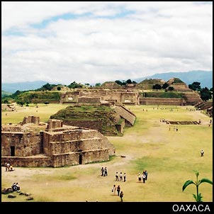
of these groups then began the monumental task of leveling the top of a 1,600
meter high mountain that intersects and divides three valley, and built Monte
Alban with a maze of subterranean passage ways, rooms, drainage and water storage
systems.
It is difficult to believe that any group other than the
long established governing power which controlled the population and resources
of the valleys below would be able to complete the task of building Monte Alban,
or that they would allow a new group of people to move right into the middle
of their territory and take up a dominant military position on the strategic
high ground controlling three valleys.
Archaeologists may still argue over who founded Monte Alban
(in spite of the oldest reliefs which are clearly Olmec), but what they do
agree on is that in the following centuries, the Zapotecans (the new people
to move into the area) were responsible for the distinct architectural style
and rise to power of Monte Alban (which coincides with the exact time period
that the powerful, war-like Olmec civilization went into full-scale decline).
Over
the years Monte Alban is known to have had contact with other cities hundreds
of kilometers away: masks and sculptures reflect contact with the Maya, and
architectural ideas were borrowed from Teotihuacan around 300 AD.
The city enjoyed two golden eras (around 100 BC to 100 AD
and 600 to 800 AD) at which time Monte Alban's population had terraced the
surrounding hillsides to support a population of close to 35,000 people spread
over a 65 hectare area.
It also had two eras of decline. The first was around 200
AD, and the second in 800 AD lead to a demise that eventually left Monte Alban
uninhabited. The reasons for this are unknown, but we know that by the beginning
of the 13th century, a people who had long coexisted with the Zapotecans, called
the Mixtec, began to expand their territory and that they reoccupied Monte
Alban.
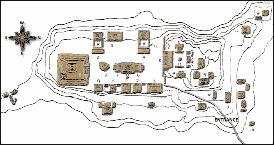
The Mixtec added little to the existing architecture at Monte
Alban, but they did leave many tombs, including Tomb 7, with its famous treasure.
Very little of the original structures at Monte Alban remain.
Most of the original buildings either had newer construction layered on top
of the older structures, or were dismantled so that their stones could be reused
for other buildings.
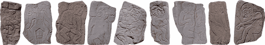
The Danzantes (The Dancers):
The oldest known structure at Monte Alban is known as The
Gallery of the Dancers. The glyphs depict naked warriors, ejaculation, childbirth,
dwarfism, captives, the sick, or the dead with contorted body positions (like
dancers). These pictures that are the oldest artifacts found here date back
to the origins of the city itself. The distinct artistic style, and the features
of the people with round mongoloid facial features and beards is pure Olmec.
The meanings of these fertility symbols, people, positions, or history is subject
to interpretation.
|